
Cartography, Jesuit Networks, and the City of the Caesars

The Emerald Empire and the Andean Athanor: Cartography, Jesuit Networks, and the City of the Caesars
Cartography, Jesuit Networks, and the City of the Caesars
The American map of Diego Gutiérrez (1562) inaugurated a long-standing tradition of recording the marvelous at the boundaries of the New World. However, by the mid-17th century, this geographical representation evolved from a passive inventory into an engine of mystical, scientific, and spiritual exploration. Through the work of the Chilean Jesuit Alonso de Ovalle, the universal theoretical framework of Athanasius Kircher, and the tragic odyssey of his disciple Nicolás Mascardi in Patagonia, the southernmost tip of America became the quintessential geopolitical and hermetic laboratory of the Baroque era. This essay examines how cartography, alchemy, lost cities, and the circulation of knowledge intertwined to transform the Kingdom of Chile into a sacred geography.
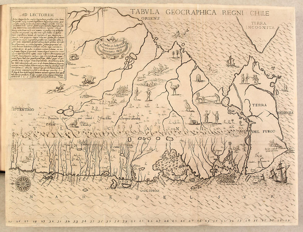
While Diego Gutiérrez's map sketched the first colossal outlines of South America, the Jesuit Alonso de Ovalle published his landmark Tabula Geographica Regni Chile in Rome in 1646. Ovalle's map did not merely update data from the House of Trade (Casa de la Contratación) in Seville; it endowed the Chilean territory with a spiritual identity. Ovalle designed a map rich in visual narratives—featuring indigenous wildlife, local flora, and native encounters—presenting Chile as a terrestrial Eden guarded by the massive wall of the Andes Mountains. This mountain range was no longer seen as just a physical barrier, but as a colossal vault of planetary riches and secrets waiting to be decoded in European intellectual capitals, particularly Rome.
The publication of Ovalle's map in Rome coincided with the golden age of the Roman College, the epicenter of Jesuit scholarship led by Athanasius Kircher. For Kircher, maps of the New World were x-rays of a hidden divine blueprint. In his treatise Mundus Subterraneus (1665), he argued that the Andean volcanoes and the deep lakes of Patagonia were floodgates for the Earth's massive internal fire (pyrophylacia) and water (hydrophylacia) systems.
This theory was not confined to European libraries. The Italian Jesuit Nicolás Mascardi, who had studied mathematics and sciences under Kircher's direct tutelage in Rome, was dispatched to the missions of Chile and Chiloé. Mascardi personified the seamless merger of Kircherian empiricism and apostolic mysticism. Equipped with the geographical understanding derived from the tradition of Gutiérrez and Ovalle, and infused with his master's theories, Mascardi crossed the Andes into present-day Argentine territory (Nahuel Huapi). His objective was not only to evangelize but to decode the mysteries of the southern geography.
Alchemy and the City of the Caesars
Within this dense intellectual ecosystem, the myth of the City of the Caesars—a chimerical metropolis hidden in Patagonian valleys boasting silver walls and golden roofs—ceased to be a mere fantasy of illiterate conquistadors. Through the lens of Baroque hermeticism and alchemy, the Caesars represented the perfect athanor: a natural crucible where the purity of matter had been preserved from worldly corruption.
To Mascardi, the quest for the Caesars (which would ultimately cost him his life in 1673) was an operation of both material and spiritual transmutation. If metals matured deep within the Earth via Kircher's central fire, a city of pure gold in Patagonia provided empirical proof that God's alchemy operated on a planetary scale. Lost cities were no longer mere targets for plunder; they were repositories of ancient knowledge and elemental purity.
The network binding Gutiérrez, Ovalle, Kircher, and Mascardi demonstrates that Baroque cartography did not merely seek to measure the world, but to consecrate it. Gutiérrez's map provided the raw spatial canvas; Ovalle granted it territorial specificity and Edenic imagery; Kircher integrated it into a universal scientific system of subterranean dynamics; and Mascardi spilled his blood upon the Patagonian steppe attempting to empirically validate this grand synthesis. Together, they reveal an era when science, alchemy, and cartography were inseparable disciplines in the relentless pursuit of absolute knowledge.
El Imperio Esmeralda y el Athanor Andino: Cartografía, Redes Jesuitas y la Ciudad de los Césares
El mapa americano de Diego Gutiérrez (1562) inauguró una tradición de registrar lo maravilloso en los confines del Nuevo Mundo. Sin embargo, a mediados del siglo XVII, esta representación geográfica dejó de ser un inventario pasivo para transformarse en un motor de exploración mística, científica y espiritual. A través de la obra del jesuita chileno Alonso de Ovalle, el marco teórico universal de Athanasius Kircher y la trágica odisea de su discípulo Nicolás Mascardi en la Patagonia, el extremo sur de América se convirtió en el laboratorio geopolítico y hermético por excelencia del Barroco.
Mientras que el mapa de Diego Gutiérrez delineaba los primeros contornos colosales de Sudamérica, en 1646 el jesuita Alonso de Ovalle publicó en Roma su Tabula Geographica Regni Chile. El mapa de Ovalle no solo actualizaba los datos de la Casa de la Contratación de Sevilla, sino que dotaba al territorio chileno de una identidad espiritual. Ovalle diseñó un mapa rico en detalles visuales —árboles, animales endémicos e interacciones indígenas— que presentaba a Chile como una suerte de Edén terrenal custodiado por la Cordillera de los Andes. Esta cordillera ya no era vista solo como una barrera física, sino como un contenedor colosal de riquezas y secretos planetarios que esperaban ser descifrados en las capitales intelectuales europeas, especialmente en Roma.
La publicación del mapa de Ovalle en Roma coincidió con el apogeo del Colegio Romano, epicentro del saber jesuítico liderado por Athanasius Kircher. Para Kircher, los mapas de América eran radiografías de un diseño divino oculto. En su tratado Mundus Subterraneus (1665), argumentó que los volcanes andinos y los lagos profundos de la Patagonia eran compuertas de los grandes sistemas de fuego (pyrophylacia) y agua (hydrophylacia) de la Tierra.
Esta teoría no se quedó atrapada en las bibliotecas europeas. El jesuita italiano Nicolás Mascardi, quien había estudiado matemáticas y ciencias bajo la tutela directa de Kircher en Roma, fue enviado a las misiones de Chile y Chiloé. Mascardi personificó la unión perfecta entre el empirismo kircheriano y el misticismo apostólico. Equipado con las nociones geográficas derivadas de la tradición de Gutiérrez y Ovalle, y con las teorías de su maestro Kircher, Mascardi cruzó la cordillera hacia el actual territorio argentino (Nahuel Huapi). Su objetivo no era solo evangelizar, sino decodificar los misterios de la geografía austral.
Alquimia y la Ciudad de los Césares
En este denso ecosistema intelectual, el mito de la Ciudad de los Césares —una quimérica metrópoli oculta en los valles patagónicos con murallas de plata y techos de oro— dejó de ser una simple fantasía de conquistadores analfabetos. Bajo la lente del hermetismo y la alquimia barroca, los Césares representaban el athanor perfecto: un crisol natural donde la pureza de la materia se había preservado de la corrupción del mundo.
Para Mascardi, la búsqueda de los Césares (que eventualmente le costaría la vida en 1673) era una operación de transmutación tanto material como espiritual. Si los metales maduraban en las entrañas de la Tierra a través del fuego central de Kircher, una ciudad de oro puro en la Patagonia era la prueba empírica de que la alquimia de Dios operaba a escala planetaria. Las ciudades perdidas dejaron de ser meros objetivos de saqueo; pasaron a ser consideradas reservorios de conocimiento antiguo y pureza elemental.
La red que conecta a Gutiérrez, Ovalle, Kircher y Mascardi demuestra que la cartografía del Barroco no pretendía únicamente medir el mundo, sino consagrarlo. El mapa de Gutiérrez proveyó la materia prima espacial; Ovalle le otorgó especificidad territorial y edenismo; Kircher la integró en un sistema científico universal de dinámicas subterráneas; y Mascardi derramó su sangre sobre la estepa patagónica buscando validar empíricamente esa gran síntesis. En su conjunto, revelan una era donde la ciencia, la alquimia y la cartografía eran disciplinas inseparables en la incansable búsqueda del conocimiento absoluto.


Comentarios