
TABULA GEOGRAPHICA REGNI CHILE 1646


ALONSO DE OVALLE - TABULA GEOGRAPHICA REGNI CHILE 1646
The map that invents Chile and puts the Caesars on the official record
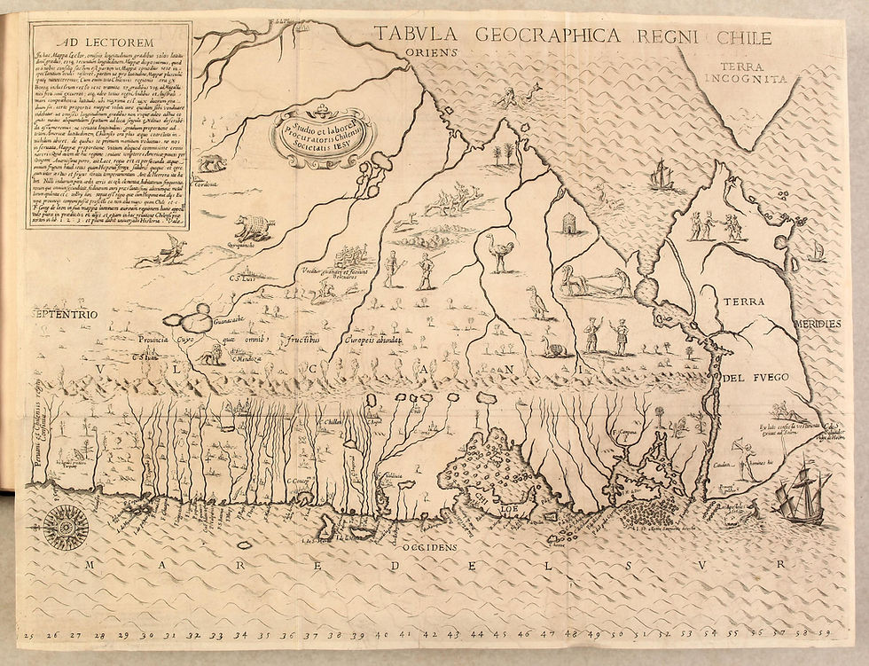
The Tabula Geographica Regni Chile is the map that accompanies the Historical Relation of the Kingdom of Chile, published in Rome in 1646 by Francisco Cavallo.
Ovalle produced two states:
Large wall version: large format —117 by 58 cm per Chilean sources, 57 x 116 cm per the John Carter Brown Library copy—. It is a horizontal, east-up map showing Chile in three sections. Only two copies survive: one at the John Carter Brown Library and one at the Bibliothèque Nationale de France in Paris as a loose sheet.
Small version: 46 x 35 cm, folded and bound inside most copies of the book. This is the one that circulated in Europe.
Intellectual author: Alonso de Ovalle, 1601-1651, Chilean Jesuit, Creole from Santiago, Procurator General of Chile to Rome and Madrid.
Engraver: Unsigned. The book's illustrations are attributed to the workshop of Antonio Tempesta in Rome. The map is a copperplate engraving on rag paper.
Financing: The Society of Jesus. Ovalle traveled to Europe 1642-1650 to recruit missionaries and funds for the Arauco War. The book and map are a fundraising dossier, dedicated to Pope Innocent X and King Philip IV. Short print run, less than 200 complete copies. This is why it is one of the rarest Americana of the 17th century.
It is the first map of Chile made by a Chilean. And the first to show Chile as an autonomous entity, not as a margin of Peru.
Chile appears as an island: bounded to the north by the Salty River, to the east by the Andes, to the west by the Pacific and to the south by the Biobío —the war frontier—. Ovalle presents it as a temperate, fertile kingdom, analogous to Europe, full of mines and medicinal plants. It is a Creole operation: to tell Europe that Chile is not a barbaric fringe, but a productive territory that deserves missionary investment.
At the same time, it divides the map into three: Chile proper, Cuyo east of the Andes, and everything south of the Biobío, which is Patagonia down to the Strait of Magellan and Tierra del Fuego. That third zone, by far the largest, is conveyed as a potential region of southward Spanish expansion.
The myth of the Caesars, giants and the fantastical.
In that Patagonia, Ovalle places, at the latitude of the destroyed Villarrica, the toponym "Los Césares". It is the first time the City of the Caesars enters official Jesuit cartography.
The city, according to legend started in 1529 with Francisco César, was a population of shipwrecked Spaniards, rich in gold and silver, in the heart of Patagonia. For 1646 it was a totally feasible reality, not a legend.
Why is the map so fantastical? Because Ovalle deliberately mixes empirical and marvelous registers, as Waldseemüller did. Alongside lava-spewing volcanoes, a penguin, a rhea, an armadillo, he draws in Tierra del Fuego an Indigenous man with a tail, adapted from Dutch voyages, and hunting scenes that are veiled metaphors for militarism. In the upper area, a sea monster is poised to devour the ram pendant of the Order of the Golden Fleece framing Philip IV's coat of arms.
That fantasy is not naivety. It is rhetoric. A map without monsters attracted no one in 1646.
The influence is direct and documented. Nicolás Mascardi, Italian Jesuit, disciple in Rome of Athanasius Kircher —author of Mundus Subterraneus—, arrives in Chiloé in 1661, reads Ovalle and his companion Diego de Rosales, and believes the discovery of the Caesars is imminent. As historian Ximena Urbina shows, for Mascardi and for all of Chiloé, the Caesars were not myth, they were an expected reality.
Ovalle gives him the geographic and theological frame. Kircher gives him the scientific frame: if there are subterranean fires connecting the planet, there can be a city under the Andes. Mascardi leaves Castro school in 1670-73 to find it, founds the Nahuelhuapi mission and dies by arrows and boleadoras at the hands of the Poyas.
Did Ovalle believe in the Caesars? He was functionally skeptical. As a Jesuit procurator, he could not deny a story that justified new missions. In his text he mentions it as news from Indians and soldiers, without affirming or denying it. He puts it on the map because the map needs a target to the south. Without Caesars, there is no reason to finance the frontier.
ALONSO DE OVALLE - TABULA GEOGRAPHICA REGNI CHILE 1646
La Tabula Geographica Regni Chile es el mapa que acompaña la Histórica Relación del Reyno de Chile y de las Missiones y Ministerios que exercita en él la Compañía de Jesús, publicada en Roma en 1646 por Francisco Cavallo.
Ovalle produjo dos estados del mismo mapa:
Versión grande mural: de grandes proporciones —117 por 58 cm según fuentes chilenas, 57 x 116 cm según medición del ejemplar de la John Carter Brown Library—. Es un mapa exento, horizontal, orientado con el Este arriba. Solo se conservan dos ejemplares: uno en la John Carter Brown Library, Brown University y otro en la Bibliothèque Nationale de France en París.
Versión pequeña: de 46 x 35 cm, plegada y encuadernada dentro de la mayoría de los ejemplares del libro. Es la que circuló en Europa.
Ambas son la misma matriz reducida. No es un mapa náutico. Es un mapa de propaganda.
Autor intelectual: Alonso de Ovalle, 1601-1651, jesuita chileno, criollo de Santiago, Procurador General de Chile ante Roma y Madrid.
Grabador: No firma. El libro fue ilustrado por el taller de Antonio Tempesta en Roma —pintor y grabador de escenas de caza y batallas—. El mapa fue abierto en cobre en Roma, en calcografía, impreso sobre papel de trapo.
Financiación: La Compañía de Jesús. Ovalle viajó a Europa entre 1642-1650 como procurador para conseguir misioneros y limosnas para la guerra de Arauco. El libro y el mapa se financian como dossier de fundraising: se dedica al Papa Inocencio X y al Rey Felipe IV. No hay impresor comercial, es una edición jesuita de autor.
Tiraje: Muy corto. La Histórica Relación se imprimió simultáneamente en español e italiano en 1646. Se estima en menos de 200 ejemplares completos. Por eso hoy es de las obras americanas más raras del siglo XVII.
Es el primer mapa de Chile hecho por un chileno. Y el primero que muestra a Chile como una entidad autónoma, no como margen del Perú.
Chile aparece como una isla: limitado al norte por el Río Salado, al este por los Andes, al oeste por el Pacífico y al sur por el Biobío —frontera de guerra—. Ovalle lo presenta como un reino templado, fértil, análogo a Europa, lleno de minas, plantas medicinales y ríos navegables. Es una operación criolla: decirle a Europa que Chile no es un confín bárbaro, sino un territorio productivo que merece inversión misional.
Al mismo tiempo, divide el mapa en tres: Chile propio, Cuyo —al este de los Andes— y todo lo que está al sur del Biobío, que es Patagonia hasta el Estrecho de Magallanes y Tierra del Fuego. Esa tercera zona, la más grande, es presentada como territorio de futura expansión española.
El mito de los Césares, los gigantes y lo fantástico.
En esa Patagonia, Ovalle sitúa, a la altura de la destruida Villarrica, el topónimo “Los Césares”. No es un adorno. Es el origen de la cartografía oficial de la Ciudad de los Césares.
La ciudad, según la leyenda iniciada en 1529 con Francisco César, era una población de españoles naufragados, rica en oro y plata, en el corazón de la Patagonia. Para 1646 era una creencia totalmente factible, no una leyenda.
¿Por qué es tan fantástico el mapa? Porque Ovalle mezcla deliberadamente registro empírico y registro maravilloso, como lo hacía Waldseemüller. Junto a volcanes en erupción, pingüinos, ñandúes y armadillos —quirquinchos—, dibuja en Tierra del Fuego a un hombre con cola, tomado de los viajes de Spilbergen, y escenas de caza que son metáforas de la guerra. En la esquina superior, un monstruo marino intenta devorar el Toisón de Oro del escudo de Felipe IV —un chiste visual jesuita contra el poder real—.
Esa fantasía no es ingenuidad. Es retórica. Un mapa sin monstruos no atrae a nadie en 1646.
La influencia es directa y documental. Nicolás Mascardi, jesuita italiano, discípulo en Roma de Athanasius Kircher —el autor del Mundus Subterraneus—, llega a Chiloé en 1661, lee a Ovalle y a su compañero Diego de Rosales, y cree que el hallazgo de los Césares es inminente. Como dice la historiadora Ximena Urbina, para Mascardi y para toda Chiloé, los Césares no eran mito, eran una realidad esperada.
Ovalle le da el marco geográfico y teológico. Kircher le da el marco científico: si hay fuegos subterráneos que conectan el planeta, puede haber una ciudad bajo los Andes. Mascardi sale del colegio de Castro en 1670-73 a buscarla, funda la misión del Nahuelhuapi y muere flechado por poyas.
¿Ovalle creía en los Césares? Era escéptico pero funcional. Como jesuita procurador, no podía negar una historia que justificaba nuevas misiones. En su texto la menciona como noticia de indígenas y soldados, sin afirmarla ni negarla. La pone en el mapa porque el mapa necesita un objetivo al sur. Sin Césares, no hay razón para financiar la frontera.


Comentarios