
The wandering city that invented Chile


THE CITY OF THE CAESARS – The wandering city that invented Chile
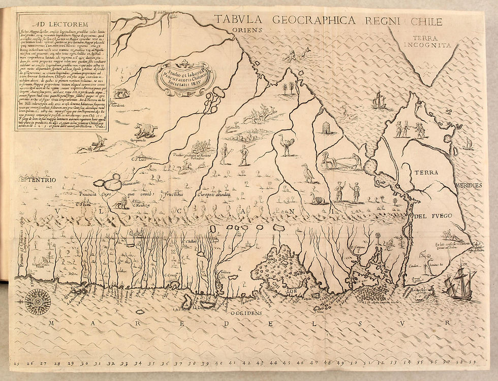
The founding myth of Patagonia is not a place. It is a displacement. And its first official inscription in Chilean cartography is Alonso de Ovalle's Tabula Geographica Regni Chile of 1646.
The myth is born in 1528, not in Chile, but in the Río de la Plata.
Sebastián Cabot, in command of a Spanish expedition, ascends the Paraná River. He sends his captain Francisco César westward, to search for the famous Sierra de la Plata. César does not find the sierra; he returns months later with a story: he claims to have reached a very rich city, with streets of gold and silver, in the interior, inhabited by very civilized Indians who worshipped a cross. It is what he heard, not what he saw. He brings a nugget as proof.
That account —César's derrotero— merges in the 1540s with another real shipwreck: the Bishop of Plasencia's expedition in 1539-40 to the Strait of Magellan. Two ships are lost, 200 Spaniards are abandoned on the Patagonian coast. From Santiago it is thought: if they survived, they founded a city. The union of the two stories creates Los Césares: the descendants of Francisco César and the castaways of the Bishop waiting to be rescued.
Ovalle, in 1646, does not invent the city. He makes it official. He places it on his map at the latitude of the destroyed Villarrica, because he needs an argument for Rome to finance missions to the south.
Chile is not explored southward to know. It is explored to rescue.
From 1604 to 1712 there are more than 15 land and sea expeditions whose explicit objective is "to discover the Caesars". Without that myth, there is no reason to cross the Biobío Frontier. The Crown does not finance curiosity; it finances souls of lost Spaniards and gold.
It is foundational because it creates the idea that the interior of Patagonia is not empty, but hides a civilization. That is why Ovalle draws Chile as a fertile island and Patagonia as a promise. Everything that comes after —Mascardi in 1670, who dies searching for it, Villarino in 1782, Moraleda in 1790— walks upon that promise.
The City of the Caesars is a wandering city. It is never where it was sought. It moves on maps for 300 years:
1562 Gutiérrez places it in northern Patagonia.
1646 Ovalle places it in Araucanía.
1670 Mascardi places it at Nahuelhuapi.
1746 Jesuit Quiroga places it in central Patagonia.
Its other name explains it: Trapalanda. It is not a Spanish word. It comes from Mapudungun trapan —meeting, confluence— and landa, deformation of land. Others translate it as "Land of the Dead". The name itself indicates that it is a place of confluence of stories, not of rivers.
Why Patagonia? Because Patagonia, since Pigafetta, is the place of excess. If there are ten-foot giants, there can be a city of gold. It is the space where the European norm does not apply, therefore everything is possible.
As long as it was believed to be a lost Spanish colony, the city was reachable. It had streets, a king, a chapel.
When it is confirmed at the end of the 17th century that there are no lost Spaniards, the city does not disappear. It becomes magical. It acquires a miraculous nature:
It becomes invisible. It only appears on Good Friday —Viernes Santo— or at dawn, among mists. Whoever sees it hears bells, sees towers of gold, but if he approaches, it disappears. It protects itself with a river that turns, with a hill that opens and closes. It becomes an enchanted city, like an American Atlantis. It is the mechanism of syncretism: not finding it, Chilote popular culture transforms it into a Chilote myth.
In the 19th century, the search focuses on Aysén. Why?
Because of Melimoyu. The Melimoyu volcano, 2,400 m, in the heart of Aysén, is a snow-capped stratovolcano, with shining glaciers. Chilotes said that behind Melimoyu, in an interior valley, was the city. Its glacier, seen from the sea, shines as if it were a golden dome. Its perfect conical shape recalls a citadel.
And because of the Holy Volcano. In late Jesuit cartography, near Melimoyu appears a "Holy Volcano" or "Volcano of the Caesars" that vomits fire but does not burn the city, because the city is protected. The smoke of the volcano would be the chimney of the lost city.
The story ends —and does not end— in 1775. The King's cartographer, Juan de la Cruz Cano y Olmedilla, publishes in Madrid the Mapa Geográfico de la América Meridional, the largest and most scientific map of the 18th century on South America —8 sheets, 2.3 x 1.6 meters—, commissioned by the Count of Floridablanca.
Cano y Olmedilla, enlightened and critical, writes on his map, in central Patagonia, at the latitude of Aysén: "City of the Caesars which is supposed to exist". And below: Trapalanda.
It is the last time that the official cartography of the Spanish Empire officially recognizes a city it knows does not exist. It puts "which is supposed". With that doubt, it buries it. From then on, the Caesars move from geography to literature, from expedition to engraving. Which is where my work comes in.
LA CIUDAD DE LOS CÉSARES – La ciudad errante que inventó Chile
El mito fundacional de la Patagonia no es un lugar. Es un desplazamiento. Y su primera inscripción oficial en la cartografía chilena es la Tabula Geographica Regni Chile de Alonso de Ovalle de 1646.
El mito nace en 1528, no en Chile, sino en el Río de la Plata.
Sebastián Caboto, al mando de una expedición española, remonta el Paraná. Envía a su capitán Francisco César hacia el oeste, a buscar la famosa Sierra de la Plata. César no encuentra la sierra, vuelve meses después con una historia: dice haber llegado a una ciudad riquísima, con calles de oro y plata, en el interior, habitada por indios muy civilizados que adoraban una cruz. Es lo que oyó, no lo que vio. Trae una pepita como prueba.
Ese relato —el derrotero de César— se funde en la década de 1540 con otro naufragio real: la expedición del Obispo de Plasencia en 1539-40 al Estrecho de Magallanes. Dos barcos se pierden, 200 españoles quedan abandonados en la costa patagónica. Desde Santiago se piensa: si sobrevivieron, fundaron una ciudad. La unión de los dos relatos crea a Los Césares: los descendientes de Francisco César y los náufragos del Obispo que esperan ser rescatados.
Ovalle, en 1646, no inventa la ciudad. La oficializa. La pone en su mapa a la altura de Villarrica destruida, porque necesita un argumento para que Roma financie misiones al sur.
Chile no se explora hacia el sur por conocer. Se explora por rescatar.
Desde 1604 hasta 1712 hay más de 15 expediciones terrestres y marítimas cuyo objetivo explícito es "descubrir los Césares". Sin ese mito, no hay razón para cruzar la Frontera del Biobío. La Corona no financia curiosidad, financia almas de españoles perdidos y oro.
Es fundacional porque crea la idea de que el interior de la Patagonia no es vacío, sino que esconde una civilización. Por eso Ovalle dibuja Chile como isla fértil y a la Patagonia como promesa. Todo lo que viene después —Mascardi en 1670, que muere buscándola, Villarino en 1782, Moraleda en 1790— camina sobre esa promesa.
La Ciudad de los Césares es una ciudad errante. Nunca está donde la buscaron. Se mueve en los mapas 300 años:
1562 Gutiérrez la pone en el norte de la Patagonia.
1646 Ovalle la pone en Araucanía.
1670 Mascardi la pone en el Nahuelhuapi.
1746 el jesuita Quiroga la pone en el centro de la Patagonia.
Su otro nombre lo explica: Trapalanda. No es palabra española. Viene del mapudungun trapan —reunión, confluencia— y landa, deformación de landa o tierra. O de Thap Al Anta, tierra de los muertos. Otros lo traducen como "Ciudad de los Patos" o "Tierra de los Césares". El nombre ya indica que es un lugar de confluencia de relatos, no de ríos.
¿Por qué Patagonia? Porque Patagonia, desde Pigafetta, es el lugar del exceso. Si hay gigantes de tres metros, puede haber una ciudad de oro. Es el espacio donde la norma europea no rige, por lo tanto todo es posible.
Mientras se creyó que era una colonia española perdida, la ciudad era alcanzable. Tenía calles, rey, capilla.
Cuando se confirma a fines del siglo XVII que no hay españoles perdidos, la ciudad no desaparece. Se vuelve mágica. Adquiere una naturaleza milagrosa:
Se vuelve invisible. Solo aparece el Viernes Santo —Viernes Santo, no "voernes"— o al amanecer, entre nieblas. Quien la ve oye campanas, ve torres de oro, pero si se acerca, desaparece. Se protege con un río que da vueltas, con un cerro que se abre y se cierra. Se convierte en una ciudad encantada, como la Atlántida americana. Es el mecanismo del sincretismo: al no encontrarla, la cultura popular chilota la transforma en mito chilote.
En el siglo XIX, la búsqueda se focaliza en Aysén.
Por el Melimoyu. El volcán Melimoyu, de 2.400 m, en el corazón de Aysén, es un estratovolcán siempre nevado, con glaciares que brillan. Los chilotes decían que detrás del Melimoyu, en un valle interior, estaba la ciudad. Su glaciar, visto desde el mar, brilla como si fuera una cúpula de oro. Su forma cónica perfecta recuerda a una ciudadela.
Y por el Volcán Santo. En la cartografía jesuita tardía, cerca del Melimoyu aparece un "Volcán Santo" o "Volcán de los Césares" que vomita fuego pero no quema la ciudad, porque la ciudad está protegida. El humo del volcán sería la chimenea de la ciudad perdida.
La historia termina —y no termina— en 1775. El cartógrafo del Rey, Juan de la Cruz Cano y Olmedilla, publica en Madrid el Mapa Geográfico de la América Meridional, el mapa más grande y científico del siglo XVIII sobre Sudamérica —8 hojas, 2,3 x 1,6 metros—, encargado por el Conde de Floridablanca.
Cano y Olmedilla, ilustrado y crítico, escribe en su mapa, en plena Patagonia central, a la altura de Aysén: "Ciudad de los Césares que se supone existir". Y más abajo: Trapalanda.
Es la última vez que la cartografía oficial del Imperio Español reconoce oficialmente una ciudad que sabe que no existe. La pone "que se supone". Con esa duda, la entierra. A partir de ahí, los Césares pasan de la geografía a la literatura, de la expedición al grabado. Que es donde entra mi trabajo.


Comentarios